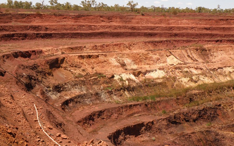
Pit slope angles at BHP Billiton’s ore body 25 went from 20 degrees to 26 or 27 degrees. Courtesy of Pells Sullivan Meynink
The original slope design for the pit wall of BHP Billiton Iron Ore (BHPBIO)’s Ore body 25 in the Pilbara, Western Australia, used a relatively simple geological model. Created in 2009, it assumed that underlying shale-dominated bedrock was overlain by detrital rock and soil deposited by the gradual erosion of nearby areas. A similarly simple hydrogeological model added information about groundwater flow.
But keeping the simple design would have been a costly error for the company.
BHPBIO recently opted for a finer-grained understanding of both the hydrology and the geology, which bolstered the case for steepening the pit wall.
BHPBIO’s geotechnical team conducted a site investigation between December 2012 and early 2013 to obtain new pit wall samples. This new drilling provided a unique opportunity to re-interpret the boundaries of soil horizons (or layers), understand the soil characteristics of these layers better, prove shear strength and measure hydrogeological properties of critical units like the clay using piezometers. The information was analyzed by BHPBIO’s geotechnical and hydrogeological engineers to create a consistent model, which was used to define slope stability.
Concurrently, the engineering consultancy Pells Sullivan Meynink (PSM) undertook a review of core photographs for Ore body 25 and identified four geotechnical units overlying the bedrock. Each represented a depositional event, and was expected to have distinct engineering properties.
PSM began interpreting the boundaries between the different geotechnical units in the pit wall of the ore body based on variations in the quantitative mineralogy. In particular, there was a focus on one potentially unfavourable clay unit in the core. Based on its unique geochemical signature, information from cored boreholes could be correlated to non-cored ones. In addition to traditional assays, spectroscopic geochemical data was assessed to provide supporting evidence of correlations in development of the geological model. An assessment of ratios of particular minerals in the assays allowed PSM to interpret the likely origin of the clay as the result of a millennia-old landslide, thereby providing inferences towards its strength and permeability characteristics.
PSM also refined the geological interpretation of soil horizons based on chemical and spectral signatures that were captured from chips from the drilling campaign. The consultancy produced a new geological model using Maptek’s Vulcan software and delivered these lithological boundaries to BHPBIO in north-south geological sections with “strings” or “layers” representing the upper boundary of similar soil/rock horizons. PSM also delivered 3D surfaces for each soil/rock horizon.
BHPBIO used the new lithological boundaries to refine the geotechnical and hydrogeological boundary conditions that were loaded in geotechnical software to optimize slope angles. The new geotechnical and hydrogeological model conducted by BHPBIO indicated lower pore pressure at a similar shear strength and capacity to hold a steeper angle.
Spectroscopic inquiry
BHPBIO had used spectroscopy to gather quantitative mineralogical data since 2009, chiefly to validate estimates made during drill-hole logging. The new study was not started with the intent of reanalyzing data, said Helen Baxter, associate engineering geologist at PSM. But as her team looked at the geochemical data, they realized it might be more useful than originally thought. “So we did a bit more research to try to get as much as we could out of the data that we had,” she pointed out.
The youngest three geotechnical units were a polymictic conglomerate, a monomictic conglomerate and a mix of breccia and kaolinitic clay. The fourth unit was a thick layer of clay, which was of particular importance in this study due to its thickness and the fact that it had previously been shown to have poor strength conditions.
PSM used geochemical data collected through traditional assays and infrared spectroscopy to interpret the likely origin of the clay and help calibrate the geological boundaries used in BHPBIO’s work. “If we have an understanding of what the origin is, it gives us a rough idea of how consolidated it is and what the possible permeability should be through it,” Baxter explained. “So then a hydrogeologist could calibrate the piezometric data that we have to see that it does actually represent what we’re thinking.”
The mining company collected chip and core samples from the nine boreholes drilled for the study, undertook both standard assays, and scanned the chips with the HyLogger infrared system developed by Australia’s CSIRO, using algorithms that quantified iron minerals, clay minerals, and other markers and contaminants including gibbsite, white mica, carbonate, silica, chlorite, and amphibole. “Standard geotechnical modelling practice is to use core data as the basis,” said Baxter. “Very few include reverse circulation holes – where chips are the resulting product.”
These marker minerals offer clues about the origin of the materials under study. For example, white mica is common in bedrock shale and less common in detrital material. For this project, there were three options for the origin of the clay unit that had been identified: it could be a very weathered (residual) part of the shale bedrock, it could be detrital in origin, or it could have arrived in its current location as failure debris from a landslide of bedrock shale that had then been overlaid by detrital deposition. PSM concluded through mineralogical comparative studies that the clays were likely failure debris.
Baxter said this was the first time she was aware of that the origin of a clay body in the Pilbara had been interpreted. That meant there was no existing data from other sites for comparative purposes, so establishing the origin was a matter of ruling out possibilities by comparison to known bedrock and detrital clays from a different deposit.
She explained: “Looking at those analogies and differences, we said, ‘OK, we’re seeing enough relationship with the bedrock here, but not enough to say that it’s a residual material.’”
A small part of a big picture
“Overall, it may have been a project where we didn’t really need to know the origin of the clay,” Baxter added, “but it gave us that extra bit of support for the other components of the project that went into the overall stability assessment. By having that understanding that the clay was most likely to be landslide material, that gave us an idea of how, geometrically, it should be shaped within the basin.”
An educated assessment would suggest that clay mobilized by landslide would be less consolidated, having been less compressed over the geological period, and that it might exhibit more voids, which would improve its ability to drain water.
Ruling out an alluvial or colluvial detrital origin confirmed that strength and hydrological data from other BHP Billiton sites in a similar geological setting could not be used in any analysis.
Baxter also observed that the dataset was broadened by using geochemical analysis on rock chips from existing exploration drilling and the holes drilled for this project. “If we had left the model to be developed using only cored holes and no geochemistry, we would have reduced the overall quantity of drilling data available for inclusion in the model significantly,” she pointed out.
The new geological model, based on geochemistry and spectral analysis, improved the interpretation of soil/rock boundaries and resulted in better representation of geotechnical and hydrogeological conditions, prompting a change in the angle of the slope to 26 or 27 degrees from 20 degrees, a lower stripping ratio and millions of dollars in savings once construction was underway in 2013 (it wrapped up early this year). “We left a significant amount of waste in the walls by stepping up the inter-ramp angle by about seven degrees,” noted Arturo Maldonado, principal geotechnical engineer at BHPBIO. He estimated that the cost of the study was completely paid off within the first few days of resuming mining operations.
A rare opportunity
There are limited precedents for this type of work. PSM had done it only once before, at a silver mine where drilling did not reveal major structural boundaries, but geochemistry did.
“PSM developed the idea of recognizing these soil horizons based on chemical signatures,” said Maldonado. “However, it was envisaged by BHPBIO that the geochemical model should be accompanied by geotechnical characterization of soils to really interpret the strength properties of these materials, particularly the clay unit.”
For her part, Baxter said the most interesting aspect of this work was having a client who signed off on research. “They allowed us to really put some geological thinking into what was going on, and get the best outcome for the project,” she said. “Using the geochemistry is something we’ve been pioneering with BHPBIO, and [is] well and truly outside the scope of what is done normally in geotechnical fieldwork.”