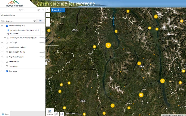
GeoScience BC's new database allows for public NI 43-101 technical reports to be searched by location for the first time. Courtesy of Geoscience BC.
Under its initiative to advance science and innovative geoscience technology, Geoscience BC made four announcements regarding its recent project and research accomplishments on Jan. 18 at AME’s Roundup convention.
In a new project, Geoscience BC was able to extract public geoscience and mineral deposit data with National Instrument 43-101 (NI 43-101) technical reports, submitted to the Canadian Securities Administration and made them more readily accessible, searchable, and locatable on a map.
The project updated 2,763 mineral occurrences data contained within 996 NI 43-101 reports in MINFILE, a public geological location and information inventory database in British Columbia and added sets of coordinates to each report so that they can be searched in Geoscience BC’s Earth Science viewer.
“National Instrument 43-101 reports are tremendously valuable to anyone assessing a property, but previously you could not search for them by location. That meant it was all too easy for information about a property to be missed,” Christa Pellett, vice-president of minerals at Geoscience BC, told CIM Magazine.
“This project has made finding the information for nearly 1,000 reports so much easier. We hope that this small step makes accessing 43-101 reports from BC projects more efficient and encourages some new investment in British Columbia.”
Keeping with the theme of creating easy accessibility, over 2,000 samples of minerals and rocks from the Smithers Exploration Group’s (SEG) Rock Room were captured in high-resolution, three-dimensional imaging and are now available to view online on an interactive map which includes summary and data information for each specimen.
The digitization of the collection has numerous benefits, according to Pellet. Not only does it increase access and create value for anyone who cannot visit the room in person (which is especially important during the COVID-19 pandemic); it will preserve information about specimens in case samples goes missing or are destroyed; rocks can take up a lot of physical space, so digitally capturing them can give the option to “keep” a sample that would otherwise be discarded; and it will also allow samples to be incorporated into interactive maps and presentations for research, training and knowledge-sharing purposes.
The non-profit organization also has a new report on a project that developed a modified regional geochemical survey (RGS) sampling strategy. The new approach that integrates the collection of bulk stream-sediment samples and derived mineralogical information, was developed from a set of collected and analyzed samples from 98 sites in southeast British Columbia.
Related: A recent Geoscience BC study sampled treetops for halogen elements to detect underground mineral deposits
“[This was] designed to improve existing geochemical coverage, add valuable mineralogical information to the existing RGS database and can enable relatively larger areas to be effectively assessed for mineral deposits,” said Pellett.
She added that there are numerous opportunities in the future to apply the survey technique in the province, including in regions that have not yet been surveyed and areas where sample-site densities have undervalued mineral assessments or have inadvertently misrepresented geochemical results.
“Applying this cost-effective method when conducting new surveys and in-fill sampling initiatives, will further the utility of the existing RGS database as an exploration tool for the discovery of hidden mineralization,” said Pellett.
Lastly, Geoscience BC released its annual Summary of Activities 2020 volumes, composed of 31 technical papers on all active minerals and energy and water research projects done by the organization throughout the year.
The mineral summaries aimed at finding new opportunities for natural resources, while the research papers on energy and water concentrated on topics like promoting the responsible development of natural resources, encouraging clean energy and understanding water. The oil and gas papers looked into expanding the understanding of induced seismicity and mitigation techniques.