Ancient cartographers drew unknowns in unmapped areas as dragons. Today, geologists face their own dragon on maps: the unknown of whether or not geophysical anomalies contain metal resources. While dragons never claimed any medieval explorers, most exploration companies will succumb to the dangers of the unknown.
Geophysical anomalies only sometimes contain metal resources, and geologists drill those anomalies in search of economic mineralization. However, during exploration phases, drilling every geophysical anomaly is an indiscriminate, expensive approach. Drilling multiple anomalies has high costs: 40.3 per cent of overall cost of exploration process to commercial mine development, as surveyed by Natural Resources Canada in 2019, was the cost of diamond drilling. Random drilling is not effective in finding mineral prospects, and it provides low odds of producing a mine. According to Prospectors & Developers Association of Canada (PDAC), only one in 10,000 identified mineral prospects will lead to a new mine.
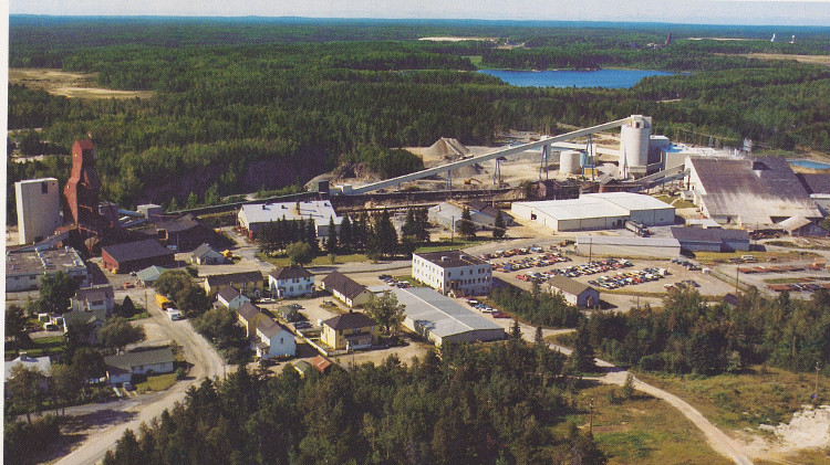
Aside from the seasonal delays, random exploration drilling is an open-ended process that creates delays and leaves an impression that the end of the line will never be found. These delays are a recipe for disenchantment by investors. An open-ended process also leads to other infrastructure costs, such as the extensive road building required to support core rig placement in new areas.
Geological data mining offers an alternative to random exploration drilling. It can be used as a tool for assessing the potential value of drilling a geophysical anomaly, turning an open-ended process of randomly drilling geophysical anomalies into a more focused process.
With geological data mining, where data is classified and used to create a prospectivity map, drilling occurs where data mining algorithms predict higher levels of success in finding ore bodies as associated with certain anomalies and economic assays of metals. This approach can reduce drilling areas down to 1.5 per cent of that used by drilling randomly.
Data mining is a better forecasting method to predict ore body interception in a wide area, accelerating the NI 43-101 process. Geologists will tend to be more on task in identifying ore as part of the NI 43-101 process. Enough ore body defined at this stage means more defining of underlying ore body shape and reaching a point where mine funding can occur.
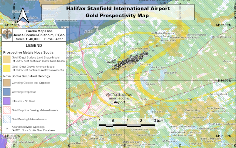 The several hundred historic gold mine shafts coincide with a data mined surface gold model, seen as an orange classification on the map. This view is a subset of a prospectivity map across the Maritimes in Canada. This surface model is combined with a separate deeper gravity anomaly data mining model (yellow classification) that shows deeper potential gold deposits underlying the surface deposits, which contain more structural details as classifications. Courtesy of Eureka Maps Inc.
In terms of data collected during exploration, no additional information is needed to carry out geological data mining by industry and government. There is enough information collected today to make this work for international level exploration. Typical data collected during exploration, such as lithogeochemistry data, gravity measurements to produce bouguer gravity anomaly maps, digital elevation maps, and to a much lesser extent in usefulness for data mining, aeromagnetic data, are all useful for data mining models. Only the assessment process changes to identify ore-body-containing anomalies, not data collected.
What does the end product look like? The figure (above) shows a classification map of a historic gold mining area immediately north of the Halifax International Airport, Nova Scotia.
This combined method can identify mines that go from shallow to deep using a stacked data mining methodology, where two entirely different data mining models are stacked on top of each other. A surface data mining gold model, based on the shape of the land and lithogeochemistry, showing more easily reached gold resources at high grade, and a deeper gravity anomaly model, based on lithogeochemistry data shows more structure details of where the gold originates.
This same technique of stacking different data mining models also works for copper, cobalt, nickel, palladium and rare earth metals.
As a method to pre-assess drilling, drilling programs focusing only on data-mined classified areas of geophysical anomalies that are forecasted to contain potential ore is a game changer in terms of accelerating mine development while reducing other impacts. Geological data mining holds the secret to surviving the dragons of the unknown: it can prevent explorers from stumbling blindly into the dragons’ dens.
James Cormier-Chisholm is a geologist and owner of Eureka Maps Inc., a geological data mining company.