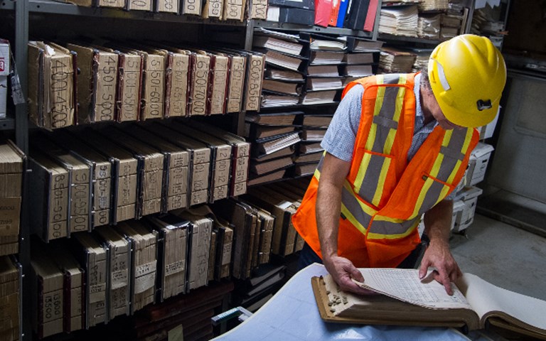
François Chabot, manager of operations and engineering at Integra Gold, consults material left behind by previous owners of the Sigma mine. Behind him are the record files for each and every drill hole since 1939. Valerian Mazataud
Vancouver-based Integra Gold kicked off a crowdsourcing competition in September in the hopes of uncovering hidden value at a recently acquired Quebec property.
The company officially launched its Gold Rush challenge on Sept. 18, in which anyone in the world is invited to analyze historical mining data for Integra’s Sigma-Lamaque property in Val-d’Or, Quebec, and locate the next gold deposit. Once registered, competitors can download the data on the HeroX crowdsourcing platform and gain free access to Leapfrog 3D geological modelling software. One week after the opening, 1,200 people from 65 countries had registered and more than half had already downloaded the data. They have until Dec. 1 to submit their suggested targets for a chance to win prizes ranging from $10,000 to $500,000 for first place, for a total value of one million dollars.
Six geologists will judge the submissions: Neil Adshead, investment strategist at Sprott Asset Management; Andrew Brown, chief geologist of West Africa for B2Gold; Benoît Dubé, senior research scientist at the Geological Survey of Canada; James Franklin, retired chief scientist of the Geological Survey of Canada; David Rhys, consulting geologist at Panterra Geoservices; and Brian Skanderbeg, president and CEO of Claude Resources.
The Sigma-Lamaque property includes two formerly separate mines: Placer Dome’s Sigma mine and Teck’s Lamaque mine. Placer Dome merged them in 1993. Over their 60 years of existence, they produced more than nine million ounces of gold. The property still holds 586,000 ounces of Measured and Indicated Resources.
When Integra’s team acquired the mining complex from the struggling Century Mining Corporation for $8 million in October 2014, it received a list of every asset included in the deal. But when the team members walked into the exploration office, they found a number of external hard drives left behind by the previous owner. These included 75 years of raw data, going back to as far as September 1939.
“There were many millions of dollars worth of data compilation that was done by the previous owners,” said George Salamis, Integra’s chairman. “They never actually got a chance to use it because they went bankrupt.”
RELATED: Names to Know 2017: George Salamis, executive chairman at Integra Gold
Most of this data consisted of high-resolution scanned images of old paper files that Sigma had accumulated over the course of the century, and which are still shelved in a small room of the Sigma-Lamaque complex. For the most part, they consist of tables with information on every hole that was drilled. These scans amounted to six terabytes (TB) of data.
According to Salamis, going through the data would require tens of thousands of work hours. “We could have given this data to our geologists to work on, but they would get distracted from their work at the Triangle Zone,” said Salamis, referring to an area just south of the Lamaque mine that has already shown very good drilling results. “They concluded that it would take many years of compilation and analysis to come to a reasonable conclusion [on the property’s potential].”
Geologists are already busy at the Lamaque property analyzing results from the winter and summer drilling campaigns, in addition to carrying out the ongoing drilling program. “Our priority is the Triangle Zone, so we concentrate on it,” said Integra COO Langis St-Pierre. “This is where we have the best chances to open a mine in the short term. That doesn’t mean that we won’t do anything with what will come out of the contest.”
Data mining
Integra is not the first mining company to use crowdsourcing as an exploration tool. Goldcorp, under the leadership of Rob McEwen, launched a similar contest in 2000 that led to the discovery of more than $6 billion worth of gold under the Red Lake mine. The operation only cost the company $575,000 in prizes, while the mine became one the largest gold producers in Canada.
“Rob and Goldcorp were the true innovators of this method in the mining sector,” said Salamis.
From paper files to 3D shapes
Crowdsourcing the Sigma-Lamaque files was not easy. First, Integra had to turn six TB of scanned images into something more palatable in the form of digitized geological models. It contracted Val-d’Or-based InnovExplo, a service provider for the mining sector, to turn the 2D images into 3D files. The job was labour-intensive, according to Salamis. “For every drill hole that was in the database, they had to go back and find a record on paper that they could match it with,” he explained. “If they didn’t find it, the hole was not used.”
In the end, the whole operation mobilized 12 people over the three summer months. By August, the six TB had been compressed to 25 gigabytes (GB). The contract was worth “hundreds of thousands of dollars,” said Salamis.
To complicate things further, the Lamaque and Sigma operators, which did not talk to each other much before their merger in 1993, used different units of measurement in their respective logs. Over its lifetime, to indicate ore grades, for example, Sigma used ounces per tonne, grams per tonne, pennyweights per tonne and even dollars per tonne, with the gold prices of the time. The Lamaque side used mostly ounces per tonne. The two mines also used different grid systems to locate drill holes. “We had to standardize the data and that was a big job,” said Salamis.
Even though the database was reduced to 25 GB, Integra could not host it on its own server, so it teamed up with Amazon Web Services. “Had we done this ourselves,” noted Salamis, “we would have crashed our server for sure.”
Integra is looking “for more than the obvious,” he went on to say. “We are looking for specific recommendations or specific targets, and a geological, statistical or mathematical reasoning as to why these are the best targets to test. It is not enough to put an arrow on a map that says: ‘Drill here.’”


