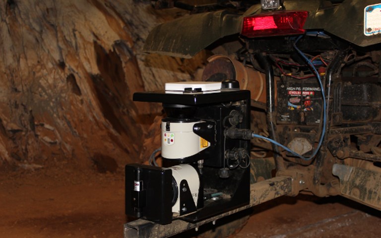
Peck Tech’s uGPS Rapid Mapper is mounted on a vehicle and emits infrared beams upward and outward as it is driven through mine tunnels, collecting data it will use to create a 3D point-cloud model. Courtesy of Peck Tech Consulting
Barrick Gold surveyors have been using mobile mapping technology to quickly produce detailed images of the underground workings at the Turquoise Ridge mine in Nevada for the past year and a half. The vehicle-mounted uGPS Rapid Mapper uses the same infrared beams as stationary LiDAR technology, but is capable of capturing much longer scans in a fraction of the time. Barrick is now working with the commercial vendor, Peck Tech Consulting, to make improvements that would allow integration into the existing surveying system.
“The Rapid Mapper, as it stands today, evolved over the past decade out of a product that was designed to provide high-precision localization for underground or GPS-deprived environments,” said Andrew Chapman, technical manager of mining solutions at Peck Tech. The first commercial product to go on the market focuses on the first step required for underground localization: creating a three-dimensional map.
How it works
Turquoise Ridge agreed to test out the technology in mid-2014 and has been using it since then. Peck Tech and Barrick – which provided seed funding for the product – had decided early on that a mine should be able to use the technology with its existing infrastructure. The vehicle-mounted device has a wireless hotspot that creates a local area network. A user can open up the browser on any wireless-enabled device and navigate to the user interface, which is hosted onboard the device.
At Turquoise Ridge, surveyors use an old Panasonic Toughbook. The surveying tool itself “weighs about 20 pounds, and we just bolt it to the bumper of our tractor,” said Tim Somers, chief mine surveyor at Turquoise Ridge.
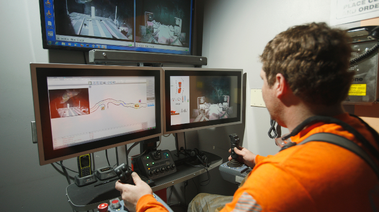
“You drive up to where you want, you open up your laptop or cell phone, you hook up to the Wi-Fi. It looks just like a webpage, basically. And you tell it you want to do a scan, and you start driving.”
The scanning process emits a rapid succession of infrared beams on two different planes – upward and outward – and registers distances based on the time it takes for these beams to bounce back. The movement of the vehicle is accounted for by proprietary and highly optimized motion estimation algorithms. The Turquoise Ridge surveyors usually drive at about two miles an hour. The slower the pace, the more detail Rapid Mapper can pick up.
When the surveyor stops the vehicle and presses the “End scan” button, the file is automatically saved on the device’s hard drive. At the end of the shift, the surveyor uploads the data onto a USB stick, returns to the office and plugs it into a computer for post-processing. The software Peck Tech provides converts the raw data into a three-dimensional point cloud.
To interpret the point cloud, Turquoise Ridge bought Maptek’s I-Site software. The points are triangulated into apparent solids, then compared to drift designs in Vulcan.
How it helps
Turquoise Ridge has found a number of uses for the technology, all related to its ability to generate detailed volume measurements from the point cloud. First off, it can validate the results of conventional LiDAR stationary scanning. “The [uGPS] scanner says that overall, we’re usually off about two and a half per cent,” said Somers. “That’s pretty acceptable to most people, but it still shows that it’s a little bit more accurate using [the Rapid Mapper] because it sees every nook and cranny.”
Rapid Mapper takes in more detail because it operates continuously. “If you don’t move [a conventional scanner] a few times, it will have what we call ‘shadows,’” explained Somers. “If you have a high spot in the drift and you’re back down the drift, it may not see that high spot because there’s a chunk of rock in the way; whereas if you move up, then you see that hole in the back.”
Moving a conventional LiDAR station can be slow. Peck Tech has found the difference can be as great as 10 minutes versus eight hours for certain use cases.
Accuracy is helpful if the operations team wants to check whether miners are matching their actual drift construction to the design dimensions. It also came in handy when an excavation had to contain eight different fuel tanks. “We scanned the area, and then we actually made 3D images of the tanks and then tried to fit them in, and found out there was no way they were going to fit,” said Somers. “So from that image, we were then able to show the miners what they had to trim off to fix that drift so that all those tanks would fit in there.”
Chapman also pointed out that by scanning the same area repeatedly, surveyors could potentially detect tunnel convergence over time, an important indicator of ground stability for geotechnical engineers.
Challenges
While the system is very useful for surveying short distances, it is not yet ready to replace conventional surveying at Turquoise Ridge. Its dead-reckoning position estimation drifts away from its actual location as it travels, at a small but constant rate.
Chapman said that motion estimation was one of the biggest challenges in getting the product ready for commercial use. “We estimate our position based on where we are currently and with a bunch of different sensor information,” he said. “We use the valuable feedback from our users to continuously improve on our algorithms, and in turn, scan accuracy.”
Peck Tech did design a way for Rapid Mapper users to periodically reorient the device. The idea is that the mine installs RFID tags at regular intervals along the tunnels and then scans a nearby point to assign each tag a specific location. Once all that information is in the system, rolling past any RFID tag will help the Rapid Mapper position itself within the mine’s coordinate system. This helps to limit drift while providing a mine map in a local reference frame familiar to mine surveyors.
Like any underground mine, Turquoise Ridge already has a system its surveyors use, based on a network of prisms in the tunnel rib. Each prism’s location is precisely known and has a specific offset effect on the infrared light that hits it, so that when the infrared bounces back, the surveyors can calculate exactly where their surveying instrument is.
As the tunnel advances, it takes 10 to 15 minutes to set each prism-based control point. Installing the RFID tag and scanning it into the Rapid Mapper takes additional time, which dissuaded Barrick from implementing the additional infrastructure. “If we have already set control we do not want to then set a different type of control for the scanner,” said Somers.
Somers said Peck Tech has been very good about coming up with fixes to issues as they arise. The current request under discussion between Turquoise Ridge, Barrick and Peck Tech is: How can the device be better integrated into the mine’s existing survey infrastructure?
The long view
The uGPS Rapid Mapper is the first commercial product to emerge from a project that started with the Mining Systems Laboratory at Queen’s University. Barrick has been closely involved in working toward the ultimate goal of an underground positioning system – hence the name uGPS – that is small and inexpensive enough to have on any vehicle underground, and that can slide into an operation without further infrastructure.
“The original benefit was for localization, but now there are opportunities for measuring difference,” explained Andrew Scott, senior director of mining information technology at Barrick.
At Turquoise Ridge, Scott and other corporate-level technologists are looking for site acceptance. So far the reaction is positive, but with some reservations.
“We realized when getting this unit that it was the first of its kind in many aspects, so we have been eager to see what comes next from this great product,” commented Mike Myers, one of the mine surveyors at Turquoise Ridge.
Meanwhile, another U.S. mine owned by Stillwater Mining has purchased a Rapid Mapper. Chapman commented that the current economic slump in the mining industry has presented some challenges, despite a base price that is roughly half that of a conventional stationary scanner. And, he added, “as a technology broker as well as a technical consulting company, we’ve seen business grow recently. And I think that’s an indicator of this paradigm shift to focus on technology as a way to increase revenues and decrease costs.”